Weather Alert in New York
Flood Warning issued March 31 at 11:58PM EDT until April 1 at 8:00PM EDT by NWS Buffalo NY
AREAS AFFECTED: Monroe, NY; Ontario, NY
DESCRIPTION: ...The National Weather Service in Buffalo NY has issued a Flood Warning for the following rivers in New York... Honeoye Creek Near Honeoye Falls affecting Monroe and Ontario Counties. For the Genesee River...including Honeoye Falls...Minor flooding is forecast. * WHAT...Minor flooding is forecast. * WHERE...Honeoye Creek near Honeoye Falls. * WHEN...From this evening to Wednesday evening. * IMPACTS...At 6.5 feet, Flood stage, flooding begins on Hyde Park Road and parking lots off West Main Street in Honeoye Falls, flooding near the intersection of County Routes 37 and 15. * ADDITIONAL DETAILS... - At 11:30 PM EDT Tuesday the stage was 6.4 feet. - Bankfull stage is 6.5 feet. - Forecast...The river is expected to rise above flood stage just after midnight tonight to a crest of 6.7 feet early Wednesday morning. It will then fall below flood stage early Wednesday afternoon. - Flood stage is 6.5 feet. - http://www.weather.gov/safety/flood
INSTRUCTION: Turn around, don't drown when encountering flooded roads. Most flood deaths occur in vehicles. Caution is urged when walking near riverbanks. Be especially cautious at night when it is harder to recognize the dangers of flooding. Additional information is available at www.weather.gov. The next statement will be issued Wednesday afternoon by noon EDT.
Want more detail? Get the Complete 7 Day and Night Detailed Forecast!
Current U.S. National Radar--Current
The Current National Weather Radar is shown below with a UTC Time (subtract 5 hours from UTC to get Eastern Time).

National Weather Forecast--Current
The Current National Weather Forecast and National Weather Map are shown below.

National Weather Forecast for Tomorrow
Tomorrow National Weather Forecast and Tomorrow National Weather Map are show below.

North America Water Vapor (Moisture)
This map shows recent moisture content over North America. Bright and colored areas show high moisture (ie, clouds); brown indicates very little moisture present; black indicates no moisture.

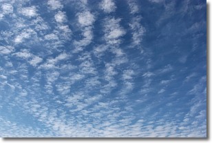
Weather Topic: What are Cirrocumulus Clouds?
Home - Education - Cloud Types - Cirrocumulus Clouds
 Next Topic: Cirrostratus Clouds
Cirrocumulus clouds form at high altitudes (usually around 5 km)
and have distinguishing characteristics displayed in a fine layer of
small cloud patches. These small cloud patches are sometimes referred to as
"cloudlets" in relation to the whole cloud formation.
Cirrocumulus clouds are formed from ice crystals and water droplets. Often, the
water droplets in the cloud freeze into ice crystals and the cloud becomes a
cirrostratus cloud. Because of this common occurrence, cirrocumulus cloud
formations generally pass rapidly.
Next Topic: Cirrostratus Clouds
Weather Topic: What are Cirrus Clouds?
Home - Education - Cloud Types - Cirrus Clouds
 Next Topic: Condensation
Cirrus clouds are high-level clouds that occur above 20,000 feet
and are composed mainly of ice crystals.
They are thin and wispy in appearance.
What do they indicate?
They are often the first sign of an approaching storm.
Next Topic: Condensation
Current conditions powered by WeatherAPI.com


