Weather Alert in New York
Flood Warning issued March 31 at 10:21PM EDT until April 2 at 11:12AM EDT by NWS Buffalo NY
AREAS AFFECTED: Erie, NY; Genesee, NY
DESCRIPTION: ...The National Weather Service in Buffalo NY has issued a Flood Warning for the following rivers in New York... Ellicott Creek Near Williamsville affecting Erie and Genesee Counties. For the Ellicott Creek...including Williamsville...Minor flooding is forecast. * WHAT...Minor flooding is forecast. * WHERE...Ellicott Creek near Williamsville. * WHEN...From Wednesday afternoon to late Thursday morning. * IMPACTS...At 8.0 feet, Flood stage, some flooding begins along Aero Drive from Holtz to Transit Roads in Cheektowaga. Also some flooding along the flood control project area in Amherst such as the bike path and golf course. Minor flooding in Ellicott Creek Park. Little or no overall damage. * ADDITIONAL DETAILS... - At 9:15 PM EDT Tuesday the stage was 4.64 feet. - Bankfull stage is 8.0 feet. - Forecast...The river will rise to 7.2 feet Wednesday morning. It will rise above flood stage Wednesday afternoon to 9.7 feet early Thursday morning. It will then fall below flood stage early Thursday morning. - Flood stage is 8.0 feet. - Flood History...This crest compares to a previous crest of 9.7 feet on 12/23/2013. - http://www.weather.gov/safety/flood
INSTRUCTION: Turn around, don't drown when encountering flooded roads. Most flood deaths occur in vehicles. Caution is urged when walking near riverbanks. Additional information is available at www.weather.gov. The next statement will be issued Wednesday morning by 1030 AM EDT.
Want more detail? Get the Complete 7 Day and Night Detailed Forecast!
Current U.S. National Radar--Current
The Current National Weather Radar is shown below with a UTC Time (subtract 5 hours from UTC to get Eastern Time).

National Weather Forecast--Current
The Current National Weather Forecast and National Weather Map are shown below.

National Weather Forecast for Tomorrow
Tomorrow National Weather Forecast and Tomorrow National Weather Map are show below.

North America Water Vapor (Moisture)
This map shows recent moisture content over North America. Bright and colored areas show high moisture (ie, clouds); brown indicates very little moisture present; black indicates no moisture.

Weather Topic: What are Wall Clouds?
Home - Education - Cloud Types - Wall Clouds
 Next Topic: Altocumulus Clouds
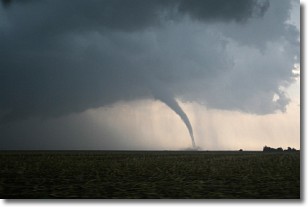
A wall cloud forms underneath the base of a cumulonimbus cloud,
and can be a hotbed for deadly tornadoes.
Wall clouds are formed by air flowing into the cumulonimbus clouds, which can
result in the wall cloud descending from the base of the cumulonimbus cloud, or
rising fractus clouds which join to the base of the storm cloud as the wall cloud
takes shape.
Wall clouds can be very large, and in the Northern Hemisphere they generally
form at the southern edge of cumulonimbus clouds.
Next Topic: Altocumulus Clouds
Weather Topic: What are Altostratus Clouds?
Home - Education - Cloud Types - Altostratus Clouds
 Next Topic: Cirrocumulus Clouds
Altostratus clouds form at mid to high-level altitudes
(between 2 and 7 km) and are created by a warm, stable air mass which causes
water vapor
to condense as it rise through the atmosphere. Usually altostratus clouds are
featureless sheets characterized by a uniform color.
In some cases, wind punching through the cloud formation may give it a waved
appearance, called altostratus undulatus. Altostratus clouds
are commonly seen with other cloud formations accompanying them.
Next Topic: Cirrocumulus Clouds
Current conditions powered by WeatherAPI.com


