Weather Alert in Arizona
Red Flag Warning issued June 19 at 8:23AM MST until June 21 at 8:00PM MST by NWS Flagstaff AZ
AREAS AFFECTED: Coconino Plateau; Yavapai County Mountains; Northeast Plateaus and Mesas Hwy 264 Northward; Chinle Valley; Chuska Mountains and Defiance Plateau; Little Colorado River Valley in Coconino County; Little Colorado River Valley in Navajo County; Little Colorado River Valley in Apache County; Western Mogollon Rim; Eastern Mogollon Rim; White Mountains; Black Mesa Area; Northeast Plateaus and Mesas South of Hwy 264
DESCRIPTION: MST Thu Jun 19 2025/ ...RED FLAG WARNING REMAINS IN EFFECT FROM 8 AM MST /9 AM MDT/ FRIDAY TO 8 PM MST /9 PM MDT/ SATURDAY FOR MUCH OF NORTHERN ARIZONA... * AFFECTED AREA...Locations near Alpine, Buffalo Pass, Chinle, Dilkon, Doney Park, Eagar-Springerville, Flagstaff, Forest Lakes, Ganado, Heber-Overgaard, Holbrook, Kayenta, Kykotsmovi, Pinetop- Lakeside, Prescott, Prescott Valley, Saint Johns, Seligman, Shonto, Show Low, Snowflake-Taylor, Tuba City, Valle, Whiteriver, Williams, Window Rock and Winslow. This includes portions of the Apache-Sitgreaves National Forest, Coconino National Forest, Kaibab National Forest, Prescott National Forest and Tonto National Forest. * WINDS...Southwest 20 to 30 mph with gusts 40 to 50 mph. * RELATIVE HUMIDITY...5 to 15 percent. * IMPACTS...The combination of gusty winds and low humidity can cause fire to rapidly grow in size and intensity before first responders can contain them.
INSTRUCTION: A Red Flag Warning means that critical fire weather conditions are either occurring or are imminent. A combination of strong winds and low relative humidities can contribute to extreme fire behavior. Please notify field crews of this Red Flag Warning.
Want more detail? Get the Complete 7 Day and Night Detailed Forecast!
Current U.S. National Radar--Current
The Current National Weather Radar is shown below with a UTC Time (subtract 5 hours from UTC to get Eastern Time).

National Weather Forecast--Current
The Current National Weather Forecast and National Weather Map are shown below.

National Weather Forecast for Tomorrow
Tomorrow National Weather Forecast and Tomorrow National Weather Map are show below.

North America Water Vapor (Moisture)
This map shows recent moisture content over North America. Bright and colored areas show high moisture (ie, clouds); brown indicates very little moisture present; black indicates no moisture.

Weather Topic: What are Hole Punch Clouds?
Home - Education - Cloud Types - Hole Punch Clouds
 Next Topic: Mammatus Clouds
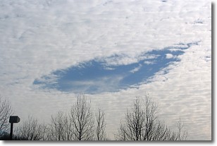
A hole punch cloud is an unusual occurrence when a disk-shaped
hole appears in a cirrostratus, cirrocumulus, or altocumulus cloud.
When part of the cloud forms ice crystals, water droplets in the surrounding area
of the cloud evaporate. The effect of this process produces a large elliptical
gap in the cloud. The hole punch cloud formation is rare, but it is not specific
to any geographic area.
Other names which have been used to describe this phenomena include fallstreak hole,
skypunch, and cloud hole.
Next Topic: Mammatus Clouds
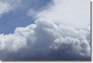
Weather Topic: What are Nimbostratus Clouds?
Home - Education - Cloud Types - Nimbostratus Clouds
 Next Topic: Precipitation
A nimbostratus cloud is similar to a stratus cloud in its formless,
smooth appearance. However, a nimbostratus cloud is darker than a stratus cloud,
because it is thicker.
Unlike a stratus cloud, a nimbostratus cloud typically brings with it the threat
of moderate to heavy precipitation. In some cases, the precipitation may evaporate
before reaching the ground, a phenomenon known as virga.
Next Topic: Precipitation
Current conditions powered by WeatherAPI.com


