Weather Alert in Arizona
Red Flag Warning issued June 19 at 8:23AM MST until June 21 at 8:00PM MST by NWS Flagstaff AZ
AREAS AFFECTED: Coconino Plateau; Yavapai County Mountains; Northeast Plateaus and Mesas Hwy 264 Northward; Chinle Valley; Chuska Mountains and Defiance Plateau; Little Colorado River Valley in Coconino County; Little Colorado River Valley in Navajo County; Little Colorado River Valley in Apache County; Western Mogollon Rim; Eastern Mogollon Rim; White Mountains; Black Mesa Area; Northeast Plateaus and Mesas South of Hwy 264
DESCRIPTION: MST Thu Jun 19 2025/ ...RED FLAG WARNING REMAINS IN EFFECT FROM 8 AM MST /9 AM MDT/ FRIDAY TO 8 PM MST /9 PM MDT/ SATURDAY FOR MUCH OF NORTHERN ARIZONA... * AFFECTED AREA...Locations near Alpine, Buffalo Pass, Chinle, Dilkon, Doney Park, Eagar-Springerville, Flagstaff, Forest Lakes, Ganado, Heber-Overgaard, Holbrook, Kayenta, Kykotsmovi, Pinetop- Lakeside, Prescott, Prescott Valley, Saint Johns, Seligman, Shonto, Show Low, Snowflake-Taylor, Tuba City, Valle, Whiteriver, Williams, Window Rock and Winslow. This includes portions of the Apache-Sitgreaves National Forest, Coconino National Forest, Kaibab National Forest, Prescott National Forest and Tonto National Forest. * WINDS...Southwest 20 to 30 mph with gusts 40 to 50 mph. * RELATIVE HUMIDITY...5 to 15 percent. * IMPACTS...The combination of gusty winds and low humidity can cause fire to rapidly grow in size and intensity before first responders can contain them.
INSTRUCTION: A Red Flag Warning means that critical fire weather conditions are either occurring or are imminent. A combination of strong winds and low relative humidities can contribute to extreme fire behavior. Please notify field crews of this Red Flag Warning.
Want more detail? Get the Complete 7 Day and Night Detailed Forecast!
Current U.S. National Radar--Current
The Current National Weather Radar is shown below with a UTC Time (subtract 5 hours from UTC to get Eastern Time).

National Weather Forecast--Current
The Current National Weather Forecast and National Weather Map are shown below.

National Weather Forecast for Tomorrow
Tomorrow National Weather Forecast and Tomorrow National Weather Map are show below.

North America Water Vapor (Moisture)
This map shows recent moisture content over North America. Bright and colored areas show high moisture (ie, clouds); brown indicates very little moisture present; black indicates no moisture.

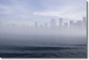
Weather Topic: What is Fog?
Home - Education - Cloud Types - Fog
 Next Topic: Fractus Clouds
Fog is technically a type of stratus cloud, which lies along the
ground and obscures visibility.
It is usually created when humidity in the air condenses into tiny water droplets.
Because of this, some places are more prone to foggy weather, such as regions
close to a body of water.
Fog is similar to mist; both are the appearance of water droplets suspended in
the air, but fog is the term applied to the condition when visibility is less than 1 km.
Next Topic: Fractus Clouds
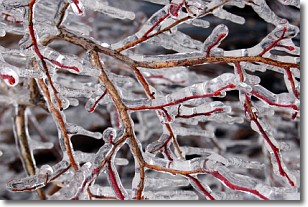
Weather Topic: What is Freezing Rain?
Home - Education - Precipitation - Freezing Rain
 Next Topic: Graupel
Freezing rain is a condition where precipitation which has fallen in the form of
water droplets reaches temperatures which are below freezing and freezes upon
coming into contact
with surface objects. The result of this precipitation is a glaze of ice which
can be damaging to plants and man-made structures. A severe onset of freezing
rain which results in a very thick glaze of ice is known as an ice storm.
Next Topic: Graupel
Current conditions powered by WeatherAPI.com


